Chopta, Uttarakhand
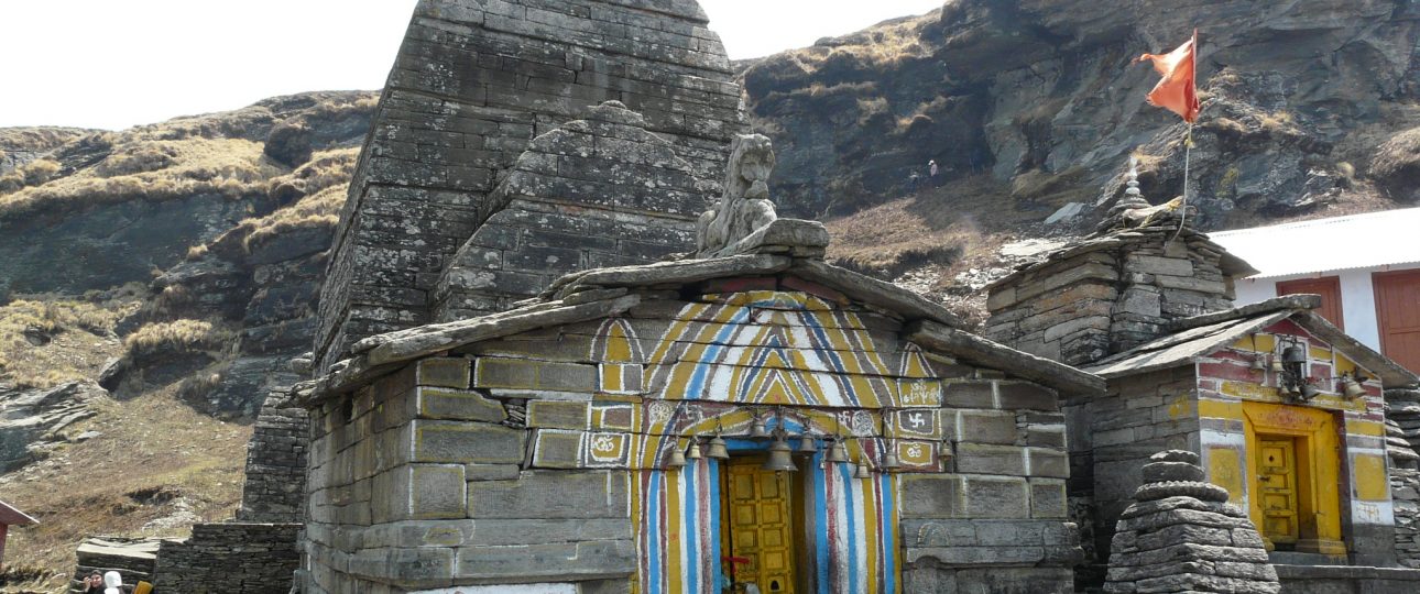
Chopta is a mountain base, not a guaranteed easy summit. Its best-known route climbs to Tungnath and then Chandrashila, combining meadow, forest, a sacred temple and a roughly 4,000-metre summit. Uttarakhand Tourism places Chopta itself around 2,608 metres. That altitude, rapid weather change and winter snow make preparation more important than the trail's popularity suggests.
The route is rewarding because several experiences overlap: Himalayan views, bird habitat, high meadows and pilgrimage. It is poor travel practice to market it simply as a beginner trek. Fitness, acclimatisation, footwear, season and current route conditions determine whether it is reasonable for you.
Understand the route before starting
Uttarakhand Tourism describes Tungnath around 3.5 kilometres from Chopta and Chandrashila another steep section above it. Its official trek document notes a well-defined path to Tungnath and a steep final ascent that can be buried in snow in winter. Distance alone understates altitude gain and exposure.
Start early enough to descend in daylight and turn around when weather, ice, fatigue or headache says so. Reaching Tungnath can be a complete and satisfying objective. The summit is optional; treating it as compulsory is how a manageable day becomes unsafe.
A responsible two-night plan
Day one: arrive and acclimatise
Reach Chopta or a nearby base in daylight, take a gentle walk and confirm the next day's trail, weather and temple status. Do not arrive late after a long drive and start climbing immediately. Eat, hydrate, organise layers and sleep.
Day two: Tungnath and an optional Chandrashila
Leave early with water, food, sun protection and warm layers. Walk at a pace that permits conversation and regular checks. At Tungnath, respect worship, footwear and photography rules. Continue to Chandrashila only if conditions, time and the whole group's health are good.
Day three: forest, birding or Deoriatal
Use the final morning for a quieter nature experience or begin the road journey rested. Deoriatal is not beside Chopta; Uttarakhand Tourism places it around 50 kilometres away via the Sari approach. Add it only with realistic transport and walking time.
Temple season and winter reality
Tungnath is a living pilgrimage site whose seasonal religious arrangements can differ from trail access. Confirm temple opening and current worship location rather than promising an open shrine every month. Dress respectfully even when trekking clothing is practical.
Winter can transform the route into a snow trek requiring traction, navigation and experienced local judgement. A viral snow video is not a conditions report. Check road access, avalanche or storm warnings and guide requirements immediately before the attempt.
Altitude, health and equipment
Headache, nausea, dizziness, unusual fatigue or poor coordination at altitude deserve attention. Stop ascending, tell companions and descend or seek medical help when symptoms worsen. Painkillers should not be used to hide a deteriorating condition and continue upward.
Wear grippy footwear already tested on long walks. Carry layered insulation, waterproof protection, hat, gloves in cold conditions, water, food, torch, basic first aid and offline navigation. In snow, use equipment and a guide appropriate to the actual route rather than improvising with city shoes.
Getting there and choosing a base
Uttarakhand Tourism cites Jolly Grant Airport about 221 kilometres away and Rishikesh rail access about 202 kilometres from Chopta. These are mountain-road distances. Buses and shared vehicles may require changes through Rudraprayag, Ukhimath or Gopeshwar; verify the live route.
Accommodation is spread among Chopta, Baniyakund, Dugalbitta, Sari and Ukhimath. Confirm exact altitude and drive to the trailhead, heating, hot water, meals, electricity and parking. A “Chopta camp” far from the start changes the morning plan.
Birding and low-impact travel
Uttarakhand Tourism highlights Chopta as important bird habitat with species including Himalayan monal and griffon. Sightings are not guaranteed. Walk quietly, keep distance, avoid playback calls and never leave food. A birding guide can make the forest more rewarding without pushing wildlife.
Pack out all waste, use toilets responsibly and avoid camps or fires that damage meadows. Meadows can look robust while being vulnerable to vehicle tracks and mass camping. Choose established services with visible waste practices.
Guides, ponies and route decisions
In snow, poor visibility or unfamiliar conditions, a competent local guide can be the difference between a safe turnaround and a bad decision. Ask about experience, group size, equipment and emergency plan. A guide should be willing to cancel or shorten the route.
Pony services may operate seasonally. If using one, assess animal condition, load, handler behaviour and trail congestion. Walking visitors should give animals space on the mountain side specified by local guidance and avoid sudden movements.
Food, water and trip cost
Do not rely on every seasonal stall being open. Carry enough water and food for the return while keeping weight reasonable. Eat a proper breakfast, but avoid alcohol before altitude and exertion. Take every wrapper down.
A realistic budget separates the long road transfer, two nights of accommodation, guide, equipment rental if needed, meals and contingency transport. Cheap snow packages often obscure poor gear or late arrival. Pay for preparation and location before decorative camp features.
Questions to answer the evening before
- Is the road to the chosen trailhead open?
- What are the overnight and summit forecasts?
- Is the temple open, and does that matter to the route?
- Where is the mandatory turnaround time?
- Does every person have layers, water, light and suitable footwear?
If one essential answer is missing, delay or shorten the plan. The mountain will remain; a fixed checkout time is not a reason to climb into deteriorating weather.
Related Himalayan planning
Longer ridge ambitions require different preparation, illustrated by Sandakphu, while Phugtal Monastery shows the access cost of remote Himalayan heritage. Tawang and Ziro Valley add permit-aware eastern Himalayan context. Return to the India hub before combining these distant regions.
Video orientation
This route overview helps visualise the road and trail. Verify its costs and conditions for your own dates.
Our verdict
Chopta is strongly recommended for prepared walkers who can accept that Tungnath—not Chandrashila—may be the correct endpoint. Stay two nights, start early and keep a conservative turnaround. Travellers seeking effortless snow or guaranteed summit views should choose another trip.
Check Uttarakhand Tourism's Chopta guide and its official trek itinerary close to departure.
Use a written turnaround plan
Record the intended start, Tungnath arrival target, latest time for Chandrashila departure and absolute turnaround. Adjust these with a competent local guide and current daylight. The rule applies even when the summit looks close. Slow pace, queueing, snow and temple time all consume the margin that a distance-only estimate ignores.
Keep the group together and decide in advance that the most conservative member's health or equipment sets the route. Do not split inexperienced walkers between summit and descent without clear leadership. A person turning back should not descend alone merely because others want the photograph.
Interpret weather rather than chasing it
Check the detailed mountain forecast, but also observe cloud build-up, wind, fresh snow and local advice. A clear dawn does not guarantee a clear summit. Thunder, whiteout, hard ice or rapid deterioration are decisive reasons to descend. Temple closure or lack of views does not justify leaving the marked trail.
After the walk
Hydrate, eat, change wet clothing and monitor symptoms. Avoid immediately starting a long night drive. A second night makes the trip safer and gives the road schedule resilience. If anyone experienced significant altitude symptoms, seek medical advice rather than celebrating with alcohol.
- Minimum stay: two nights around the region.
- Acceptable endpoint: Tungnath or an earlier safe turnaround.
- Essential equipment: light, layers, waterproofing, food, water and grip.
- Reason to cancel: unsafe road, storm, inadequate gear or illness.